6 Best Hiking and Biking Trails in Summit County
Summit County is the kind of place that makes you want to lace up your boots, pump up your tires, and head straight for the mountains. With hundreds of routes spidering through alpine valleys, forested slopes, and historic mining corridors, this corner of Colorado feels like an endless playground for hikers and bikers alike. Whether you are chasing high-altitude climbs, mellow lakeside strolls, or family-friendly loops, there is a trail here with your name on it.
This guide highlights six standout hiking and biking trails in Summit County that capture the area’s rugged beauty, diverse terrain, and unforgettable views. From quick alpine lake walks to full-day cycling challenges, these are the routes that keep outdoor enthusiasts coming back again and again.
- Wide variety of trails for different skill levels and interests.
- Mix of alpine, forest, lakeside, and historic landscapes.
- Easy access to nearby mountain towns for food, gear, and lodging.
Summit County’s Trail Experience
What sets Summit County apart is how quickly the landscape can change under your feet. One minute you are pedaling past historic cabins and old mining sites, and the next you are walking through dense pine forest with peaks towering above. Many trails weave near creeks, lakes, and waterfalls, giving you plenty of excuses to pause and soak it in.
For this guide, the focus is on trails that offer a strong mix of scenery, accessibility, and memorable features. Some are better suited for experienced hikers or cyclists, while others are perfect for families, new visitors, or travelers with limited time.
- Dynamic terrain ranging from alpine tundra to shady forest loops.
- Trails that highlight local history, wildlife, and seasonal color.
- Options for both quick outings and full-day adventures.
At-a-Glance Trail Overview
Use this quick-reference table as your starting point for planning the perfect Summit County outing. It pulls together distances, difficulty levels, and each trail’s standout features.
| Trail Name | Distance | Key Features | Difficulty |
| Spruce Creek Trail | 6.4 miles | Waterfalls, lakes, wildlife, fall colors | Hard |
| Loveland Pass Lake Trail | 0.8 miles | Alpine lake, big views, quick outing | Easy |
| Hoosier Pass Loop | 2.7 miles | Continental Divide, wildflowers, gravel | Moderate |
| Mayflower Gulch Traverse | 6.4 miles | Forest, mining cabins, summit views | Moderate |
| Ute Pass Ride | 4.9 miles | Rolling terrain, creeks, evergreen forest | Moderate |
- Handy snapshot of distance, difficulty, and highlights.
- Ideal for comparing trails and matching them to your group.
- Great jumping-off point for first-time Summit County visitors.
Spruce Creek Trail: Cascade, Climb, and Capture
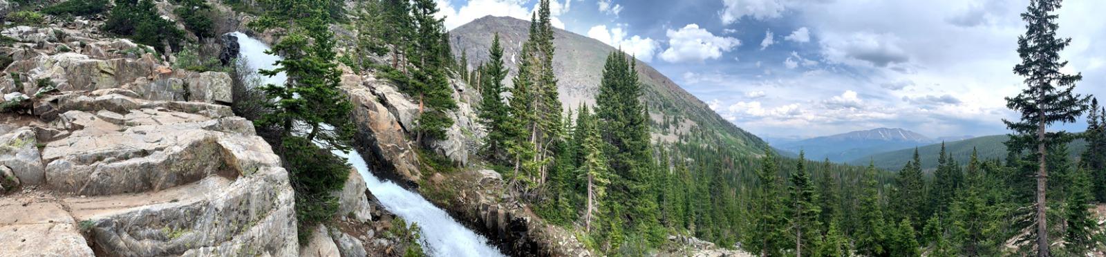
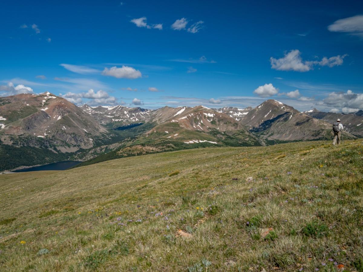
Spruce Creek Trail is the kind of hike that makes every step feel worth it. This 6.4-mile loop with about 1,788 feet of elevation gain is one of the more demanding routes in this guide, but the payoff is huge. Expect a mix of waterfalls, high-alpine lakes, dense forest, and open mountain views—plus a few relics of Summit County’s mining era.
The trail passes Continental Falls and leads toward Lower and Upper Mohawk Lakes, each offering different perspectives of the surrounding peaks and valleys. Hikers often spot deer, marmots, and songbirds along the way, especially during the quieter morning hours. In late summer and fall, the route lights up with golden aspen groves and colorful mountain shrubs. Because it can take over four hours to complete, it is important to bring plenty of water and snacks, and to start early to make the most of the daylight.
In winter, snowshoes or microspikes are strongly recommended, as the path can become icy and packed. Parking is conveniently available at the end of Spruce Creek Road, making this a relatively straightforward trailhead to find. Those who like to explore can take short side paths leading to hidden viewpoints or peaceful resting spots just off the main route.
- 6.4-mile, higher-intensity loop with waterfalls and alpine lakes.
- Brilliant fall foliage, plus frequent wildlife sightings.
- Accessible parking and quiet side paths to scenic viewpoints.
- Winter visits may require snowshoes or traction gear.
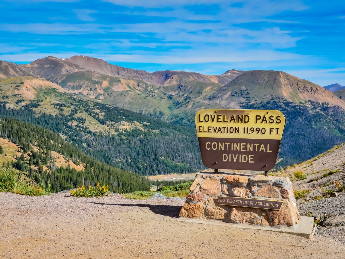
Loveland Pass Lake Trail: Alpine Serenity in Minutes

Not every epic view requires an epic trek. The Loveland Pass Lake Trail is a short 0.8-mile hike that delivers big alpine scenery with minimal effort. Beginning above the treeline, the trail gently winds toward a clear alpine lake ringed by rugged peaks and views of nearby ski slopes. With only about 85 feet of elevation gain, it is approachable for most visitors, including families and those adjusting to altitude.
This trail is ideal if you want a quick outdoor escape between other activities, or if you are easing into higher elevations before attempting more strenuous routes. The remote feel and smaller size help keep crowds lower than some other popular spots, especially if you arrive early or visit on a weekday. Snow often lingers here even during warmer months, adding to the dramatic mountain backdrop and reminding you that you really are up in the high country.
There are many spots along the shore and nearby rocks to enjoy a picnic, take photos, or simply sit and listen to the stillness of the landscape. Parking is located conveniently off Loveland Pass, so you can step out of your car and be on the trail within minutes.
- Short 0.8-mile outing with outsized alpine lake views.
- Very gentle elevation gain and broad, open panoramas.
- Easy to pair with other nearby trails in the same day.
- Snow patches may linger, helping keep crowds relatively light.
Hoosier Pass Loop: Scenic High-Altitude Adventure on Wheels
- 2.7-mile loop along the Continental Divide with big mountain views.
- Gravel surface offers a fun, moderate challenge for most riders.
- Beautiful wildflowers and well-maintained terrain in warmer months.
- Clockwise or counterclockwise routes each give unique experiences.
Hoosier Pass Loop is a 2.7-mile route that offers a satisfying balance of challenge, access, and reward, especially for biking enthusiasts who enjoy consistent effort without committing to an all-day ride. Set within Pike National Forest, the loop sits along the Continental Divide and offers wide-open views in nearly every direction.
The elevation gain—about 672 feet—feels moderate, making this trail a strong choice for those with some biking experience as well as families with active kids. The gravel surface provides a good workout for your legs while still remaining manageable for many riders. On clear days, you can look out toward surrounding peaks, Montgomery Reservoir, and the historic Mosquito Range mining area, with alpine tundra and vibrant wildflowers adding color to the route in spring and summer.
At the top of the loop, brisk winds are common, so having an extra layer can make your summit time much more comfortable. The trail can be traveled in either direction, and both clockwise and counterclockwise loops offer slightly different perspectives. In late season, certain sections can stay icy, so shoulder-season riders should take extra caution.
Mayflower Gulch Grande Traverse: A Hike Through History and Peaks
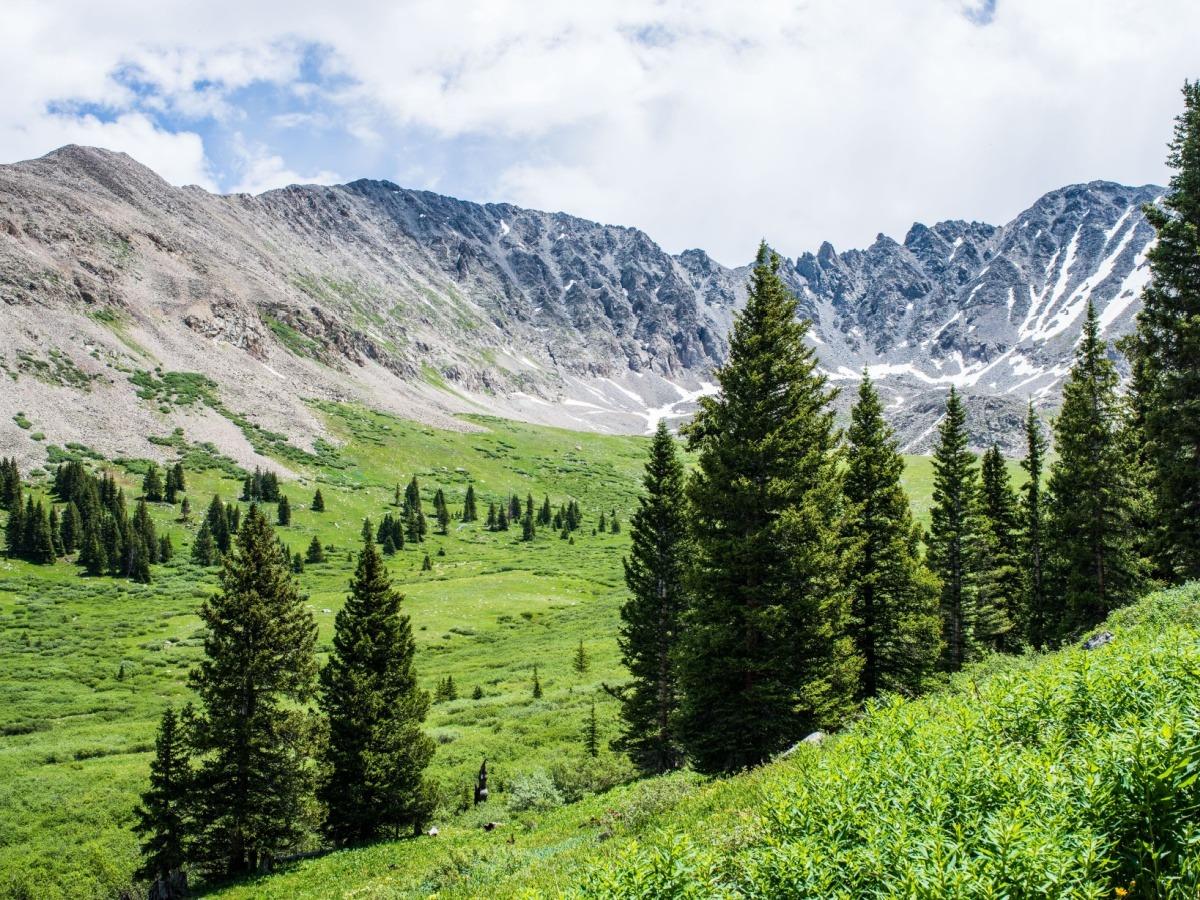
For travelers who want both natural beauty and a sense of history, the Mayflower Gulch Grande Traverse is hard to beat. This 6.4-mile out-and-back trail climbs about 1,722 feet through the White River National Forest, offering an immersive journey into the heart of Colorado’s mining and mountain heritage. The hike begins with a gradual incline that becomes steeper near the historic Gold Crest mine area, where impressive views open up around you.
Along the way, hikers walk through shady alpine forests, across open meadows, and past old mining cabin ruins that feel frozen in time. The combination of weathered wooden structures and towering peaks creates a powerful, photo-ready scene. The trail generally takes 4–5 hours at a steady pace, making it a solid half-day outing for most visitors. It is considered moderately difficult, with occasional rocky sections that may require careful footing.
The area tends to be quieter than some of Summit County’s most famous spots, so it is a good choice if you value a bit of solitude. Dogs are allowed, making it popular with travelers who enjoy exploring with four-legged companions. In early winter, icy patches appear near treeline, so sturdy footwear and possibly traction devices are recommended.
- 6.4-mile out-and-back blending forest, peaks, and history.
- Mining cabin ruins and Gold Crest mine area create memorable scenery.
- Moderate difficulty with some rocky sections and elevation gain.
- Great for those seeking less crowded trails and optional side ridgeline routes.
Ute Pass Ride: Biking Through a Serene Colorado Escape
For a route that feels both peaceful and invigorating, the Ute Pass Ride stands out as a favorite among hikers and bikers. This 4.9-mile out-and-back trail climbs about 1,020 feet through the Arapaho National Forest, mixing initial steep sections with rolling high-country terrain. The payoff is a series of sweeping panoramic views at the halfway point, where many travelers pause to catch their breath and take in the scenery.
The path passes through evergreen forests that give off a rich, refreshing scent—especially after a rain shower. Two small creek crossings add charm and provide natural water features along the route, offering a refreshing break for hikers and a cooling stop for pets. The trail is lightly trafficked compared to some more famous nearby spots, which makes it a great option if solitude and quiet are part of your ideal day outside.
Parking at the trailhead is straightforward and easily accessible, but there are no bathroom facilities, so planning ahead is essential. Many visitors prefer to tackle this ride in the early morning or late afternoon, when temperatures are more comfortable and the light is particularly striking across the mountains.
- 4.9-mile out-and-back with 1,020 feet of elevation gain.
- Lightly trafficked route with tranquil evergreen forests.
- Two creek crossings, plus wide mountain views at the turnaround.
- No on-site restrooms; best experienced in the cooler hours of the day.
Planning Your Summit County Trail Days
With such a range of trail types and difficulty levels, planning ahead will ensure you make the most of your time in Summit County. In general, the prime window for hiking and biking is from May through September, when temperatures are more comfortable and most trails are clear of deep snow. Shoulder seasons can still be rewarding but may require additional gear for snow and ice.
Many trails in the area are dog-friendly, but pets are typically required to be on a leash to protect local wildlife and preserve the shared trail experience for everyone. Bringing plenty of water, snacks, sun protection, and layers is key at these elevations, where weather can shift quickly from warm sunshine to chilly gusts.
- Best overall trail conditions are usually May–September.
- Many routes welcome dogs, but leashes are strongly emphasized.
- Extra water, layers, and sun protection are must-haves in high-altitude terrain.
Stay, Explore, and Return Again
We find that every visit to Summit County feels fresh and inspiring, even when we return to explore our favorite trails all over again. The changing seasons bring new perspectives. Whether we’re marveling at fresh snowfall on distant peaks, admiring bursts of fall color in the forests, or discovering new stories woven into the region’s history on every outing.
If you’re dreaming of a getaway where alpine climbs, forested loops, lakeside walks, and scenic bike rides are right outside your door, come join us in Summit County. With the right blend of trails and a warm, welcoming place to stay, every moment in the Rockies becomes as satisfying as the unforgettable views.
We invite you to stay with us at Summit County Mountain Retreats. Our collection ranges from ski-in/ski-out condos to spacious mountain homes across Keystone, Breckenridge, Copper, Dillon, Frisco, and Silverthorne. Make your next adventure even more rewarding by booking with us.